


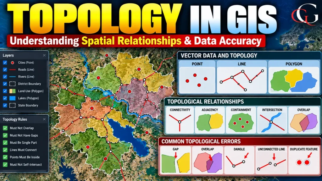
Why is Topology Important in GIS?
In a Geographic Information System (GIS), spatial data is not only about where features are located, but also about how those features are related to one another. This concept is known as topology.
Topology is particularly important when working with vector data such as points, lines and polygons. It helps GIS identify relationships such as which polygons share a boundary, which roads connect with each other, and whether two areas overlap incorrectly.
For example, if two adjacent districts share a common boundary, that boundary should normally be represented consistently by both polygons. A topological GIS dataset can detect errors such as gaps, overlaps, disconnected roads and duplicate boundaries. Thus, topology is an important component of GIS data quality, spatial analysis and mapping.
What is Topology in GIS?
Topology in GIS refers to the rules and relationships that define how geographic features connect, share boundaries, overlap or are adjacent to one another. Unlike simple geometric information, which records coordinates and shapes, topology focuses on the spatial relationships between features.
For example:
- A road connects to another road.
- A river passes through a region.
- Two administrative areas share a boundary.
- A building is inside a particular land parcel.
- Two land-use polygons should not overlap when they represent mutually exclusive classes.
These relationships allow GIS software to perform more reliable spatial analysis.
Basic Topological Relationships
1. Connectivity
Connectivity describes whether line features are properly connected. For example, a road network should contain connected road segments at intersections. If two road segments appear to meet visually but their endpoints do not actually connect, network analysis may produce incorrect results.
Example: Road-network analysis and shortest-path calculations.
2. Adjacency
Adjacency describes whether two polygons share a common boundary. For example, two districts may be adjacent if they have a common border. Example: Administrative boundary mapping and neighborhood analysis.
3. Containment
Containment describes whether one feature lies inside another. For example, a village may lie inside a district, while a district lies inside a state. Example: Determining which district contains a particular school or village.
4. Intersection
Intersection occurs when spatial features cross or meet. For example, a road may intersect a river, or two utility lines may cross each other. Example: Identifying roads crossing flood-prone areas.
5. Overlap
Overlap occurs when two features occupy the same spatial area. In some datasets, overlap is valid. In others, it represents an error. For example, two land-use polygons classified as different mutually exclusive categories should generally not overlap.
Why is Topology Important?
Topology improves GIS data quality and spatial accuracy. It is particularly important for:
- Cadastral mapping
- Administrative boundaries
- Road networks
- Utility networks
- Land-use mapping
- Urban planning
- Hydrological analysis
- Transportation planning
- Disaster management
For example, in a cadastral GIS, overlapping land parcels or gaps between parcels can create serious problems. Topological rules help identify and correct these inconsistencies.
FAQs
1. What is topology in GIS?
Topology is the set of spatial relationships between geographic features, such as connectivity, adjacency, containment and overlap.
2. What are common topology errors in GIS?
Common errors include gaps, overlaps, dangles, duplicate features and unconnected lines.
3. Why is topology important in GIS?
Topology improves spatial-data quality and helps ensure that geographic features maintain correct relationships for reliable mapping and analysis.


