




Why is it in News?
The idea of creating a digital replica of Earth is moving from research toward operational environmental applications. In June 2026, the European Union’s Destination Earth (DestinE) initiative entered its third phase, running from June 2026 to June 2028. The programme is developing highly detailed digital twins that combine Earth-system models, observations, supercomputing and artificial intelligence.
The latest phase focuses on further developing the Climate Change Adaptation Digital Twin and Weather-Induced Extremes Digital Twin, while advancing AI-based Earth-system modelling. In May 2026, a new generation of Climate Digital Twin simulations was also released, covering global climate conditions for 1990–2049.
This development is important for GIS because it moves spatial analysis beyond simply mapping what exists today toward exploring what could happen tomorrow.
What Is a Digital Twin of Earth?
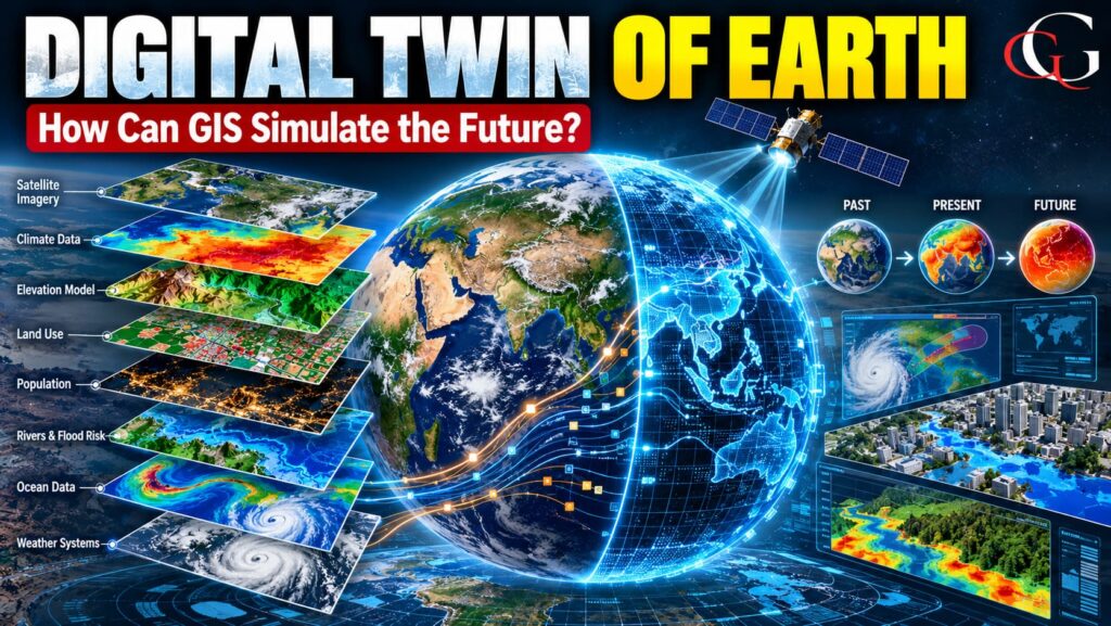
A Digital Twin of Earth is a computer-based representation of the Earth system that combines observations, geographical data, physical models and computing to reproduce and simulate changes in the real world.
Think of it as a virtual Earth laboratory.
Instead of waiting for a heatwave, flood or drought to occur, scientists can use digital-twin technology to explore different scenarios—for example:
- What could happen if global temperatures rise further?
- How might a flood spread across a city?
- Which areas could face greater drought risk?
- How could changing rainfall affect agriculture?
- What happens to sea ice under different climate conditions?
DestinE describes its digital twins as systems that can explore tailored “what-if” scenarios and provide information from global to local scales.
How Does GIS Help?
GIS provides the spatial framework needed to understand these simulations. A digital twin can combine enormous amounts of data from:
Satellite imagery + GIS layers + Weather observations + DEMs + Sensors + Climate models + AI
GIS can then integrate these datasets according to their location, scale and time. For example, suppose a digital twin simulates a future flood. GIS can overlay the predicted flood extent with:
- population density
- roads and railways
- hospitals
- settlements
- agricultural land
- drainage networks
- elevation
This transforms a climate simulation into a geographical impact assessment. Therefore, GIS does not itself “predict the future.” Rather, it helps organize, analyse, visualize and communicate spatial information generated by models and observations.
From 2D GIS to 4D Digital Earth
Traditional GIS commonly represents geographic information in 2D, such as roads, rivers, land use and administrative boundaries.
Modern geospatial systems increasingly add:
3D → height and terrain
4D → geographic change through time
A Digital Twin of Earth goes further by combining space + time + physical processes + simulations. For example, instead of simply mapping a river, a digital twin could simulate how river discharge and flood extent change hour by hour under a particular rainfall scenario.
Why Is It Significant?
1. Climate-change adaptation
Digital twins can help governments test possible climate scenarios and identify vulnerable regions before major impacts occur. DestinE’s Climate Digital Twin is specifically designed for multi-decadal climate simulations and adaptation applications.
2. Disaster management
The Weather-Induced Extremes Digital Twin can simulate extreme events such as heavy rainfall and other hazards at high resolution, supporting preparedness and response.
3. Smart cities
Urban planners can potentially combine digital elevation models, buildings, transport networks, population and climate information to examine future urban risks.
4. AI + GIS
DestinE is also developing machine-learning components for land, ocean, sea ice, waves and hydrology, showing how AI is becoming integrated with Earth-system modelling.
The Future of GIS
The evolution can be understood simply:
Traditional GIS → 3D GIS → 4D GIS → GeoAI → Digital Twin of Earth
The major change is that GIS is increasingly becoming part of a dynamic decision-support system, rather than only a tool for creating static maps.
Digital twins will not provide a perfect prediction of the future. Instead, they allow scientists and planners to explore physically consistent possible futures, understand uncertainty and compare different scenarios. DestinE itself describes its simulations as tools for exploring possible evolutions and “what-if” questions.
Sources: ECMWF,
Frequently Asked Questions
1. What is a Digital Twin of Earth?
It is a computer-based representation of the Earth system that combines observations, models, geospatial data and computing to simulate possible changes.
2. What is the role of GIS in Digital Twin technology?
GIS integrates, analyses and visualizes spatial data from satellites, sensors and models, helping users understand where future environmental impacts may occur.
3. What is Destination Earth (DestinE)?
DestinE is a European Union initiative developing high-resolution digital twins of the Earth system for understanding climate change, extreme events and possible future scenarios.


