





Why is it in News?
The U.S. Geological Survey (USGS) released new data in September 2026 projecting potential coastal bluff retreat and erosion in Puget Sound, Washington, under changing conditions and sea-level rise. The study uses historical retreat rates, geology, bluff height, nearshore slope and wave energy to identify areas that may become vulnerable.
This brings attention to an important physical-geography feature: the bluff.
What Is a Bluff in Geography?
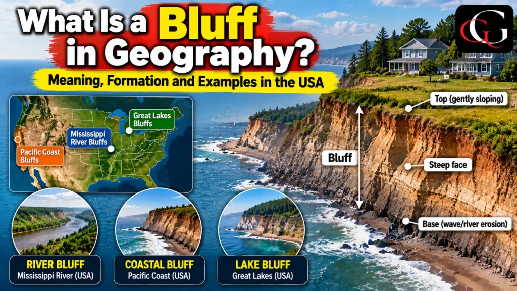
A bluff is a broad, steep-sided or rounded cliff-like landform, commonly found along rivers, lakes, beaches and coastlines. Unlike a classic vertical cliff, a bluff often has a more gently sloping or rounded profile. National Geographic describes a bluff as a type of broad, rounded cliff that commonly borders a river, beach or coastal area
Bluffs may develop in unconsolidated or weakly consolidated sediments such as sand, silt, clay and glacial deposits. Because these materials are relatively susceptible to erosion, bluffs can retreat over time. USGS vegetation-classification information also identifies erosional bluffs with exposed alluvial or wave-eroded sediments
How Does a Bluff Form?
1. River Erosion
Bluffs can form along meandering rivers. Water flowing around the outside of a river bend has greater erosive power and gradually removes material from the riverbank. As the lower part of the bank is undercut, the unsupported upper material may collapse, producing a steep bluff.
The Mississippi River provides a classic U.S. example. In parts of the Upper Mississippi Valley, the river flows through valleys bordered by bluffs that may rise 50–100 metres above the river and floodplain.
2. Coastal and Lake Erosion
Along coastlines and large lakes, waves attack the base or toe of a bluff. Once the toe is eroded, the upper slope can become unstable and retreat inland. NOAA research has documented bluff erosion along the Great Lakes, while coastal bluffs are also vulnerable to waves, storms and changing water levels.
3. Weathering and Mass Movement
Rainfall, groundwater, freeze-thaw processes and surface runoff can weaken bluff materials. Eventually, slumping, landsliding or collapse may cause the bluff face to move backward.
Geographic Significance of Bluffs
Bluffs are important indicators of erosion and landscape change. Their location and shape provide clues about river processes, coastal dynamics, geology and past environmental conditions.
In the United States, bluffs are particularly significant along the Mississippi River, Great Lakes and Pacific coast. For example, USGS projections for Puget Sound use bluff height, geology, wave power and historical retreat to assess future coastal vulnerability.
Bluff retreat can also affect roads, houses, farmland, recreational areas and other infrastructure. Therefore, understanding bluff formation is important not only in physical geography but also in coastal planning, hazard management and property development.
Frequently Asked Questions
1. What is a bluff in geography?
A bluff is a broad, steep or rounded cliff-like landform commonly found beside rivers, lakes and coastlines.
2. What is the difference between a bluff and a cliff?
A cliff is generally steeper and may be nearly vertical, whereas a bluff is often broader and more gently sloping or rounded.
3. Where are famous bluffs found in the USA?
Important examples occur along the Mississippi River, Great Lakes and Pacific coast, including the bluffs of Minnesota and Puget Sound.