




Estimated reading time: 14 minutes
When we study the population of a country, it is not enough to know simply how many people live there. Geography is equally concerned with where people live, how they are distributed across space, and why some regions support large concentrations of population while others remain sparsely populated.
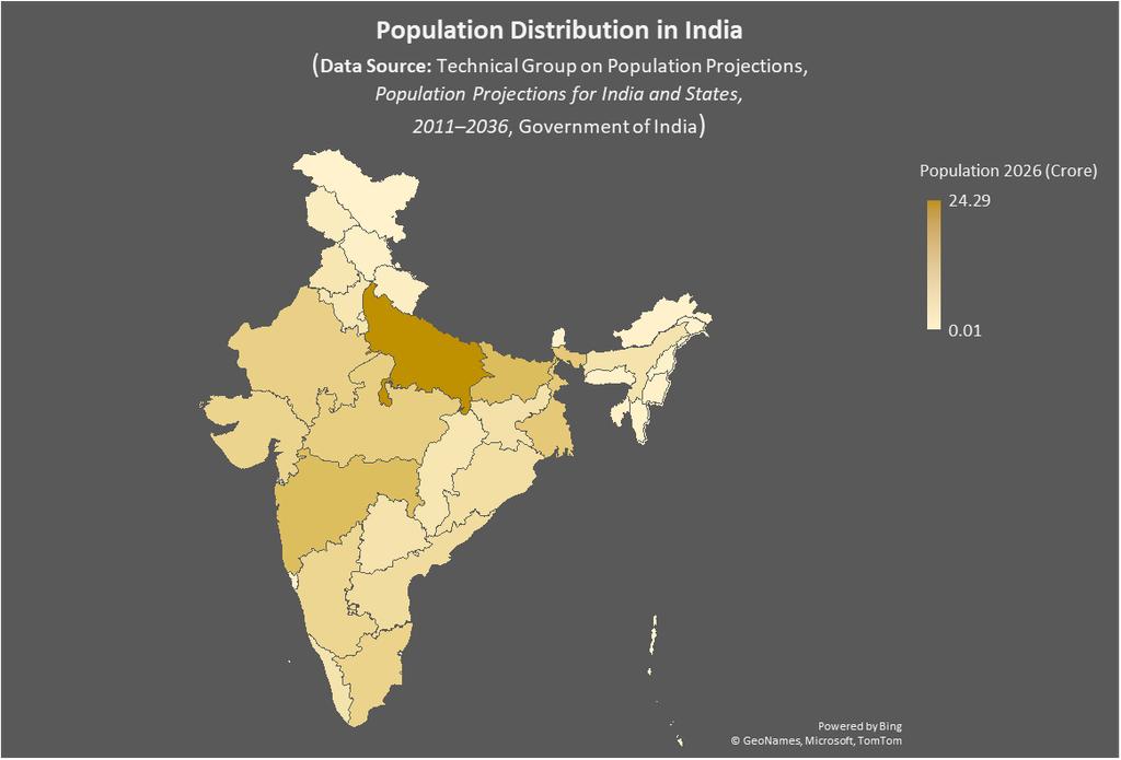
India provides one of the clearest examples of uneven population distribution. The population is not spread uniformly across the country. Very large concentrations of people are found in the fertile plains of northern and eastern India and around major urban-industrial centres, whereas the high Himalayas, the Thar Desert, the high-altitude regions of Ladakh and several north-eastern hill areas have comparatively sparse populations.
This uneven distribution is not the result of a single factor. It has developed through the interaction of relief, climate, water availability, soil fertility, agricultural development, historical settlement, transport, industrialisation, urbanisation, migration and employment opportunities.
Therefore, population distribution in India should be understood as a spatial expression of the relationship between people, environment and economic development.
What is Population Distribution?
Population distribution refers to the spatial arrangement or geographical spread of people over a particular area.
In simple terms, it answers the question: Where do people live?
Population distribution should be distinguished from population density. Distribution describes the spatial pattern of population, while density expresses the number of people living per unit area, usually per square kilometre.
| Concept | Meaning |
| Population Distribution | Where people are located across geographical space |
| Population Density | Number of people per unit area |
| Population Concentration | Relative accumulation of population in particular areas |
For example, Uttar Pradesh has a very large population, but population is not equally distributed throughout the state. Similarly, Rajasthan has a large geographical area, but its population is concentrated more strongly in areas with better water availability, agriculture, transport and urban development.
Census Population and Projection Population
| Before discussing India’s population distribution, an important distinction needs to be made between Census population and projected population. The 2011 Census is the latest completed population Census of India. Official Census data are available through the Census of India Population Finder. For the period after 2011, the Government of India has published population projections through the Technical Group on Population Projections, 2011–2036. These projections provide estimated population figures for India, States and Union Territories. Thus, the 2026 figures presented below should be understood as projected population, not as population counted through a 2026 Census. |
Projected Population of Indian States and Union Territories, 2026
| State / Union Territory | Type | Projected Population 2026 (Million) | Approx. Population (Crore) |
| Uttar Pradesh | State | 242.859 | 24.29 |
| Bihar | State | 132.265 | 13.23 |
| Maharashtra | State | 129.308 | 12.93 |
| West Bengal | State | 100.522 | 10.05 |
| Madhya Pradesh | State | 89.673 | 8.97 |
| Rajasthan | State | 83.642 | 8.36 |
| Tamil Nadu | State | 77.546 | 7.75 |
| Gujarat | State | 74.086 | 7.41 |
| Karnataka | State | 68.962 | 6.90 |
| Andhra Pradesh | State | 53.709 | 5.37 |
| Odisha | State | 47.147 | 4.71 |
| Jharkhand | State | 40.958 | 4.10 |
| Telangana | State | 38.636 | 3.86 |
| Assam | State | 36.717 | 3.67 |
| Kerala | State | 36.207 | 3.62 |
| Punjab | State | 31.318 | 3.13 |
| Haryana | State | 31.299 | 3.13 |
| Chhattisgarh | State | 31.211 | 3.12 |
| Jammu & Kashmir | Union Territory | 13.896 | 1.39 |
| Uttarakhand | State | 11.993 | 1.20 |
| Himachal Pradesh | State | 7.579 | 0.76 |
| Tripura | State | 4.260 | 0.43 |
| Meghalaya | State | 3.440 | 0.34 |
| Manipur | State | 3.311 | 0.33 |
| Nagaland | State | 2.294 | 0.23 |
| Puducherry | Union Territory | 1.757 | 0.18 |
| Arunachal Pradesh | State | 1.604 | 0.16 |
| Goa | State | 1.599 | 0.16 |
| Mizoram | State | 1.272 | 0.13 |
| Chandigarh | Union Territory | 1.267 | 0.13 |
| Sikkim | State | 0.708 | 0.07 |
| Andaman & Nicobar Islands | Union Territory | 0.406 | 0.04 |
| Ladakh | Union Territory | 0.305 | 0.03 |
| Lakshadweep | Union Territory | 0.070 | 0.007 |
Source: Technical Group on Population Projections, Population Projections for India and States, 2011–2036, Government of India.
Regional Pattern of Population Distribution in India
For geographical analysis, India’s population distribution can broadly be understood through four levels of population concentration:
- Very High Population Concentration
- High Population Concentration
- Moderate Population Concentration
- Low Population Concentration
These categories are analytical rather than strict administrative classifications. A state may contain more than one population pattern because geographical conditions often change within the same state.
1. Very High Population Concentration
Very high population concentration is mainly associated with the Ganga Plain and adjoining northern and eastern plains, together with major metropolitan regions such as the Delhi urban region. Uttar Pradesh, Bihar and West Bengal contain some of the most important population concentration zones of India.
The physical foundation of this concentration is the extensive alluvial plain formed by the Ganga and its tributaries. The terrain is relatively flat, soils are generally fertile and water is available through rivers and groundwater. These conditions have historically supported intensive agriculture. Crops such as rice, wheat, sugarcane, pulses and vegetables can be cultivated extensively, allowing a large rural population to derive its livelihood from the land.
However, agriculture alone cannot explain the exceptionally large population of this region. The Ganga Plain has been a major centre of human settlement for thousands of years. Ancient settlements, kingdoms, religious centres, trading towns and later colonial and modern urban centres developed in this region. Population accumulated over generations, creating a strong historical foundation for the present distribution.
In the modern period, transport networks, industries, educational institutions, government activities and services have further strengthened population concentration. Delhi and its surrounding region provide a particularly clear example of this transition. Its population concentration is strongly associated with administration, employment, industry, trade, education, transport and the expansion of metropolitan functions.
Thus, very high population concentration in northern and eastern India can best be explained through the combined influence of fertile alluvial plains, water availability, intensive agriculture, historical settlement, transport connectivity and modern urbanisation.
2. High Population Concentration
High population concentration occurs across several parts of western, southern, central and north-eastern India, particularly in regions where agricultural productivity has combined with industrialisation, urbanisation, transport development and employment opportunities. Maharashtra, Gujarat, Tamil Nadu, Karnataka, Kerala, Telangana, Andhra Pradesh, Punjab, Haryana, Odisha and Assam contain important examples of this pattern.
In western India, Maharashtra and Gujarat demonstrate the increasing importance of economic factors in population geography. Mumbai, Pune, Ahmedabad and Surat have developed as major centres of industry, finance, trade, services and transportation. Ports and commercial networks have also strengthened the economic attractiveness of the western coastal belt. As a result, population concentration around these urban centres cannot be explained simply by soil or climate.
Southern India presents a similarly complex pattern. Tamil Nadu, Karnataka, Telangana and Andhra Pradesh have developed important urban and industrial centres. Bengaluru has become a major centre of information technology and services, while Chennai and Hyderabad have developed diversified industrial and service economies. These urban centres attract migrants because they provide employment, education, healthcare and other services. Consequently, modern economic opportunities increasingly influence population distribution.
Kerala provides an interesting geographical example because its relatively high population concentration is associated with a combination of favourable climate, coastal location, intensive cultivation, historical trade, urbanisation and the growth of services. Population settlements are often dispersed rather than concentrated in only a few large cities, producing a distinctive settlement pattern.
Punjab and Haryana demonstrate another combination of factors. Fertile soils, irrigation, mechanised agriculture and high agricultural productivity have historically supported dense settlement. More recently, industrialisation, transport development and the influence of the Delhi National Capital Region have contributed to increasing urban and economic concentration in several areas.
Assam represents the influence of valley environments in a predominantly hilly region. Population is concentrated more strongly in the Brahmaputra and other favourable valley areas, where relatively flat land, fertile soils, water availability and agricultural opportunities provide better conditions for settlement than the surrounding mountainous terrain.
The common geographical feature of these areas is therefore not a single physical condition but the interaction of agriculture, urbanisation, industrial development, transport and employment.
3. Moderate Population Concentration
Moderate population concentration is characteristic of several plateau, interior and transitional regions of India. Madhya Pradesh, Chhattisgarh, Jharkhand, interior Odisha and several parts of the Peninsular Plateau illustrate this pattern, although substantial internal variations exist within each region.
The Peninsular Plateau differs from the northern plains in terms of relief and surface characteristics. It contains plateaus, uplands, valleys and dissected terrain, and the availability of fertile agricultural land varies considerably from one locality to another. Rainfall and water availability also show considerable spatial variation. As a result, settlements are generally less continuous than those of the great northern plains.
At the same time, these regions possess important economic resources. Jharkhand, Chhattisgarh and Odisha contain significant mineral resources, and mining and industrial activities have resulted in the development of towns and population concentrations around resource-rich areas. Irrigation projects, roads and industrial centres have also created localised areas of higher population concentration.
Madhya Pradesh provides a good example of regional variation within a large state. Agricultural areas, river valleys, irrigation zones and urban centres have greater population concentration, whereas extensive forested, rugged or less accessible areas have comparatively fewer people.
The important point is that moderate population concentration does not necessarily indicate an absence of favourable conditions. Rather, it often reflects a mixed geographical environment in which favourable and unfavourable conditions occur side by side.
4. Low Population Concentration
Low population concentration is mainly associated with environments where physical conditions make large-scale settlement more difficult. Important examples include the high Himalayan region, Ladakh, Arunachal Pradesh and several north-eastern hill areas, the western Thar Desert and some island territories.
The Himalayan region illustrates the influence of rugged topography particularly well. Steep slopes, narrow valleys, limited agricultural land and difficulties of transportation restrict the expansion of settlements. At higher elevations, low temperatures, snowfall and short growing seasons further reduce agricultural possibilities. Consequently, population tends to concentrate in relatively favourable valleys, terraces and accessible locations rather than being evenly distributed across the mountains.
Ladakh represents an even more extreme environment. Its high altitude, cold arid climate, limited water resources and very restricted agricultural land impose strong constraints on permanent settlement. Population is therefore concentrated mainly in accessible valleys and locations where water is available. The case of Ladakh demonstrates how extreme environmental conditions can produce a highly uneven settlement pattern even within a large geographical region.
The north-eastern hill region presents a different combination of constraints. Dense forests, steep slopes, fragmented terrain and historically limited accessibility have restricted large-scale settlement in many areas. However, valleys, plains and urban centres provide more favourable conditions, creating localised population concentrations.
Western Rajasthan is another classic example of low population concentration. The Thar Desert is characterised by low and variable rainfall, high evaporation, sandy terrain and limited water availability. These conditions have historically restricted agricultural productivity and large-scale permanent settlement. However, irrigation development, roads, urban centres and access to water have allowed population concentrations to develop in selected areas.
Island territories generally have small populations because of limited land availability, geographical isolation and restricted opportunities for large-scale agriculture and industry. Nevertheless, population may be locally concentrated around administrative, tourism and service centres.
Thus, low population concentration should not simply be attributed to “difficult terrain.” It is the combined effect of relief, climate, water availability, agricultural potential, accessibility and economic opportunities.
Population Distribution and Population Density: An Important Distinction
| Students frequently use the terms population distribution and population density interchangeably, but they represent different geographical ideas. Population distribution describes the spatial arrangement of people, whereas density measures the relationship between population and area. For example, Rajasthan has a very large geographical area and a large population, but much of its western desert region has relatively sparse settlement. On the other hand, a small urban or metropolitan area may contain a very large population within a limited area and therefore have extremely high density. Therefore: Population size, population distribution and population density are three related but different concepts. |
Conclusion
India’s population is characterised by a highly uneven spatial distribution. Very large concentrations occur in the northern and eastern plains and around major urban and economic centres, while mountainous, desert, high-altitude and isolated regions generally have lower population concentrations.
The historical population pattern of India was strongly influenced by fertile soils, water availability, agriculture and river systems. However, the contemporary pattern is increasingly being reshaped by industrialisation, urbanisation, transport connectivity, migration, services and employment opportunities.
The population map of India should therefore not be interpreted simply as a map showing where more or fewer people live. It is, in a broader geographical sense, a reflection of the long-term interaction between physical environment, human adaptation, economic development and historical processes.
The most important geographical lesson is that no single factor can adequately explain India’s population distribution. Population concentration in each region results from a particular combination of environmental opportunities, historical development and contemporary economic forces.
Thus, the study of population distribution is ultimately the study of how human beings occupy geographical space and how that spatial pattern changes with changing environmental, technological and economic conditions.
Quick Revision Table
| Population Concentration | Major Geographical Regions / Examples | Main Explanatory Factors |
| Very High | Ganga Plain, major parts of Uttar Pradesh, Bihar, West Bengal and Delhi region | Fertile alluvium, water, agriculture, historical settlement, transport, urbanisation |
| High | Maharashtra, Gujarat, Tamil Nadu, Karnataka, Kerala, Telangana, Andhra Pradesh, Punjab, Haryana, Odisha and Assam | Agriculture, industry, urbanisation, ports, transport, services and employment |
| Moderate | Madhya Pradesh, Chhattisgarh, Jharkhand, interior Odisha and parts of Peninsular Plateau | Plateau relief, variable agriculture, minerals, irrigation, industries and urban centres |
| Low | Himalayas, Ladakh, north-eastern hills, western Thar Desert and island territories | Rugged relief, climatic extremes, water constraints, limited cultivable land and accessibility |
Frequently Asked Questions (FAQs)
1. What is population distribution in India?
Population distribution in India refers to the spatial arrangement of people across different parts of the country. It is highly uneven, with very high concentrations in the northern and eastern plains and major urban-industrial regions, while mountainous, desert and high-altitude areas generally have lower population concentrations.
2. Which region of India has the highest population concentration?
The Indo-Gangetic Plain is one of India’s major areas of very high population concentration. Fertile alluvial soils, abundant water, relatively flat terrain, intensive agriculture, historical settlement and urbanisation have contributed to its dense population.
3. Why is population concentration low in the Himalayan region?
Population concentration is generally low in the higher Himalayan region because of steep slopes, rugged terrain, limited cultivable land, cold climatic conditions, difficult accessibility and restricted opportunities for large-scale economic activities.
4. What are the major factors affecting population distribution in India?
The major factors include relief, climate, water availability, soil fertility, agricultural development, mineral resources, industrialisation, transport, urbanisation, historical factors and employment opportunities. Their relative importance varies from region to region.
10 MCQs
Q1. Multiple Choice Question
Which geographical region of India is associated with very high population concentration?
A. Ladakh
B. Thar Desert
C. Indo-Gangetic Plain
D. Higher Himalayas
Answer: C. Indo-Gangetic Plain
Q2. Assertion–Reason
Assertion (A): The Indo-Gangetic Plain has a very high population concentration.
Reason (R): The region has fertile alluvial soils, extensive plains and relatively good water availability.
A. Both A and R are true, and R correctly explains A
B. Both A and R are true, but R does not correctly explain A
C. A is true, but R is false
D. A is false, but R is true
Answer: A. Both A and R are true, and R correctly explains A
Q3. Match the Following
| Region | Characteristic |
| 1. Indo-Gangetic Plain | a. Cold desert environment |
| 2. Thar Desert | b. Fertile alluvial plain |
| 3. Ladakh | c. Arid environment |
| 4. Mumbai region | d. Major industrial and financial centre |
Which option is correct?
A. 1-b, 2-c, 3-a, 4-d
B. 1-c, 2-b, 3-d, 4-a
C. 1-a, 2-d, 3-c, 4-b
D. 1-d, 2-a, 3-b, 4-c
Answer: A. 1-b, 2-c, 3-a, 4-d
Q4. Odd One Out
Which of the following is least associated with high population concentration?
A. Fertile alluvial soil
B. Intensive agriculture
C. Availability of water
D. Extremely rugged terrain
Answer: D. Extremely rugged terrain
Q5. Concept-Based MCQ
Which statement best distinguishes population distribution from population density?
A. Distribution measures birth rate, while density measures death rate
B. Distribution describes where people live, while density expresses population per unit area
C. Distribution measures migration, while density measures urbanisation
D. Distribution and density are exactly the same concepts
Answer: B. Distribution describes where people live, while density expresses population per unit area
Q6. Multiple-Statement MCQ
Consider the following statements:
- Fertile soils can support intensive agriculture.
- Water availability can encourage settlement.
- Urbanisation can attract population through employment opportunities.
- Rugged terrain always produces high population density.
Which of the above statements are correct?
A. 1 and 2 only
B. 1, 2 and 3 only
C. 2 and 4 only
D. 1, 2, 3 and 4
Answer: B. 1, 2 and 3 only
Q7. Chronological/Process-Based MCQ
Which sequence best represents a possible process of population concentration in a favourable geographical environment?
A. Urbanisation → water scarcity → agricultural decline → settlement
B. Favourable environment → agriculture → settlement → transport and markets → urbanisation
C. Industrialisation → rugged terrain → water scarcity → agricultural development
D. Migration → desertification → fertile soil → dense settlement
Answer: B. Favourable environment → agriculture → settlement → transport and markets → urbanisation
Q8. Case-Based MCQ
A region has fertile alluvial soil, extensive flat land, a well-developed irrigation system and a long history of settlement. Which population pattern would most likely develop in such an area?
A. Very high population concentration
B. Very low population concentration
C. Completely uninhabited landscape
D. Population concentration determined only by tourism
Answer: A. Very high population concentration
Q9. Data Interpretation MCQ
According to the 2026 Government of India population projection used in the article, which state has a projected population of approximately 242.9 million?
A. Maharashtra
B. Bihar
C. Uttar Pradesh
D. West Bengal
Answer: C. Uttar Pradesh
Q10. Higher-Order Thinking MCQ
A mountainous region develops a new highway, tourism industry, hydropower projects and several service-sector centres. Which change in its population pattern is most likely?
A. Population must become uniformly distributed throughout the mountains
B. Existing environmental constraints will disappear completely
C. Population may become more concentrated around accessible economic centres
D. The region will necessarily become the most densely populated part of India
Answer: C. Population may become more concentrated around accessible economic centres