







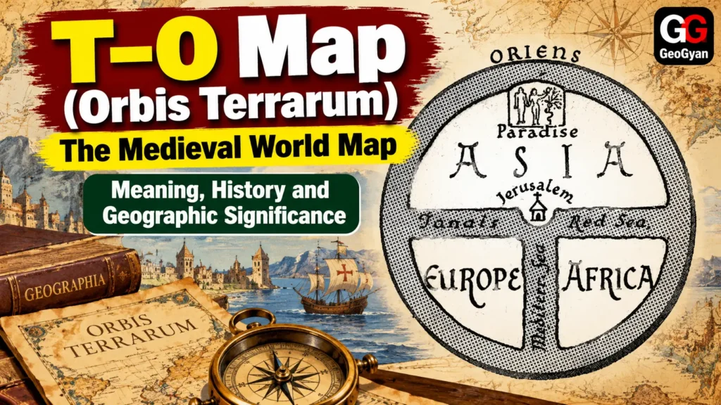
The T–O map, also known as Orbis Terrarum or the “circle of the lands,” was one of the most influential schematic representations of the known world in medieval European geography. The term *Orbis Terrarum* refers to the circular representation of the inhabited world, while T–O describes the map’s distinctive visual structure: a T-shaped arrangement of major water bodies enclosed within an O-shaped ocean. Rather than attempting to provide the precise distances and coordinates expected from a modern map, it represented the geographical knowledge and worldview of its period.
Why Is It Called a T–O Map?
The name comes directly from its appearance. The “O” represents the circular ocean surrounding the known inhabited world, while the “T” is formed by the major water bodies that divide the land into three parts. In the conventional form, the Mediterranean separates Europe from Africa, while the Nile and the Tanais (Don) separate Africa and Europe from Asia. As a result, the known landmass is divided into the three continents recognised by medieval European scholars: Asia, Europe and Africa.
The British Library explains that these maps focused on the known inhabited parts of the northern hemisphere, arranging them within a simple circular framework. This made the map less a navigational instrument and more a visual framework for organising geographical knowledge.
Orbis Terrarum and Isidore of Seville
The T–O tradition is closely associated with Isidore of Seville (c. 560–636 CE), whose influential encyclopedia *Etymologiae* described the inhabited world as divided into Asia, Europe and Africa and surrounded by ocean. T–O diagrams became closely associated with manuscripts of Isidore’s geographical writings
An important point for students is that the T–O map was not necessarily one single standardized map. It was a cartographic diagrammatic tradition that appeared in different manuscripts and later medieval *mappae mundi*. Some later versions became much more elaborate, adding cities, rivers, peoples, animals, biblical events and legendary places.
Jerusalem and the Medieval Worldview
Many detailed medieval T–O maps placed Jerusalem at or near the centre of the world. The orientation was also different from most modern maps: Asia was commonly placed at the top, with Europe toward the lower-left and Africa toward the lower-right. This arrangement reflected the intellectual and religious worldview of medieval Europe rather than modern conventions of north-up cartography. The Library of Congress notes the religious significance of the design, including the association of the T-shaped division with the Christian cross and Jerusalem’s central position.
However, it is important not to assume that every T–O map had exactly the same religious symbolism or level of detail. The earliest diagrams were relatively simple, while later *mappae mundi* incorporated increasingly complex historical, geographical and theological information.
Was the T–O Map Showing a Flat Earth?
A T–O map should not automatically be interpreted as evidence that medieval scholars believed the Earth was flat. The diagram was primarily a representation of the known inhabited world, rather than a complete physical model of the planet. The broader medieval intellectual tradition inherited the idea of a spherical Earth from classical Greek thought, and Isidore’s writings also contain evidence consistent with a spherical Earth.
Therefore, the T–O map is better understood as a schematic representation of the medieval ecumene—the inhabited or known world.
Geographic Significance of T–O Map (Orbis Terrarum)
The T–O map is important in the history of geography and cartography because it demonstrates that maps are not merely tools for locating places; they also reflect the knowledge, culture and worldview of the society that produces them.
It provides an important link between classical geography, medieval world mapping and Renaissance cartography. By comparing a T–O map with Ptolemy’s coordinate-based geography and later Renaissance maps such as Abraham Ortelius’s *Theatrum Orbis Terrarum* (1570), students can clearly see the transformation of cartography from symbolic representations of the known world toward increasingly systematic and measured geographical mapping.
Sources: LOC
Frequently Asked Questions
1. What is a T–O Map?
A T–O Map is a medieval schematic world map in which the known world is represented as a “T” enclosed within an “O.” The “O” represents the surrounding ocean, while the “T” divides the known world into Asia, Europe and Africa.
2. Why is the T–O Map also associated with Orbis Terrarum?
Orbis Terrarum is a Latin expression meaning approximately “circle of the lands” or “the world.” The T–O map visually represented this medieval concept of the known or inhabited world, so the two terms are closely associated in the history of cartography.
3. Did medieval people believe the Earth was flat because of the T–O Map?
No. The T–O map was primarily a schematic representation of the known inhabited world, not a scientific model proving that Earth was flat. Medieval geographical traditions inherited the concept of a spherical Earth from classical Greek scholarship.


