


Estimated reading time: 5 minutes
In recent years, discussions around urban rewilding and climate change in New York City have brought North Brother Island back into focus. Experts now consider this abandoned island a natural laboratory for studying biodiversity recovery, rising sea levels, and coastal vulnerability. Its growing relevance in environmental debates makes it an important case study in geography and disaster management for competitive exams.
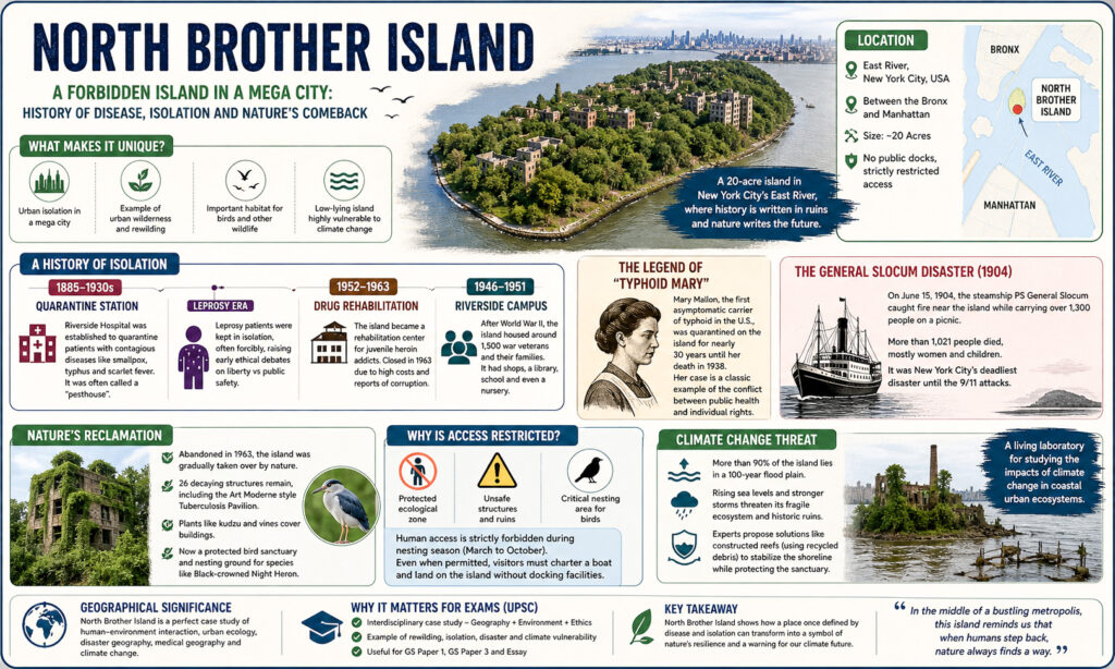
Where is North Brother Island Located?
North Brother Island is a small 20-acre landmass situated in the East River, between the Bronx and Manhattan. Despite being located within one of the busiest cities in the world, it remains completely isolated and inaccessible to the public. This unique position highlights an important geographical concept—urban isolation within a densely populated region, which is rarely seen on such a scale.
Why is North Brother Island Geographically Unique?
North Brother Island represents a powerful example of urban wilderness, where human absence has allowed nature to reclaim space. Over time, dense vegetation has covered abandoned buildings, creating a thriving habitat for various bird species. This transformation demonstrates the concept of rewilding, where ecosystems regenerate naturally without human interference. Such examples are important in geography as they show how natural processes can reverse human impact.
Why Was the Island Used for Quarantine?
The island’s isolation made it an ideal location for the establishment of Riverside Hospital in 1885, which treated patients suffering from highly contagious diseases like smallpox, typhus, and scarlet fever. It was often referred to as a “pesthouse” due to the severity of these diseases. This reflects the application of medical geography, where spatial separation is used as a strategy to control disease spread.
Who Was Typhoid Mary?
One of the most famous figures associated with the island is Mary Mallon, also known as Typhoid Mary. She was the first identified asymptomatic carrier of typhoid fever in the United States and was quarantined on the island for nearly three decades. Her case highlights the ethical conflict between individual freedom and public health safety, making it significant for both geography and ethics in competitive exams.
What Happened During the General Slocum Disaster?
In 1904, the island became the site of a tragic event when the steamship General Slocum caught fire near its shores. Over 1,300 passengers were onboard, and more than 1,021 people lost their lives, making it one of the deadliest disasters in New York’s history before 2001. This event is an important example of disaster geography, illustrating how location and preparedness influence the scale of human loss.
How Did the Island Transform After World War II?
After World War II, North Brother Island was temporarily transformed into a residential area known as the Riverside Campus, which housed around 1,500 war veterans and their families. The island had basic facilities such as schools and shops, showing how geographical spaces can undergo functional transformation over time based on societal needs.
How Did Nature Reclaim the Island?
Following its final abandonment in 1963, North Brother Island was gradually overtaken by nature. Today, the remains of around 26 deteriorating structures are covered with vegetation, and the island serves as a protected habitat for birds such as the Black-crowned Night Heron. This process reflects ecological succession, where natural ecosystems develop over time in the absence of human activity.
Why is North Brother Island Restricted Today?
Access to North Brother Island is strictly restricted due to multiple reasons. The area is declared a protected ecological zone, and the old buildings pose serious safety risks. Additionally, it is an important nesting site for birds, and human interference could disturb the ecosystem. This makes it a relevant example of environmental governance and political geography, where authorities regulate access to protect natural resources.
Is Climate Change Affecting North Brother Island?
North Brother Island is highly vulnerable to climate change due to its low elevation. More than 90% of the island lies within a flood-prone zone, making it susceptible to rising sea levels and storm surges. Experts consider it a “climate change laboratory”, as it helps in understanding the impact of environmental changes on coastal ecosystems. This connects the topic with coastal geography and climate studies.
Thus, North Brother Island is not just an abandoned piece of land but a living example of how geography shapes human history and environmental change. From being a quarantine center to becoming a thriving natural habitat, it highlights the dynamic relationship between humans and nature.
FAQs
Q1. Where is North Brother Island located?
It is located in the East River between the Bronx and Manhattan in New York City.
Q2. Why is North Brother Island abandoned?
It was abandoned in 1963 due to declining use, high costs, and safety concerns.
Q3. Who was Typhoid Mary?
She was an asymptomatic carrier of typhoid fever who was quarantined on the island.
Q4. Can tourists visit North Brother Island?
No, public access is restricted to protect the ecosystem and ensure safety.
Q5. Why is it important for geography students?
It is an important example of urban ecology, rewilding, and climate change impact.


