


Estimated reading time: 4 minutes
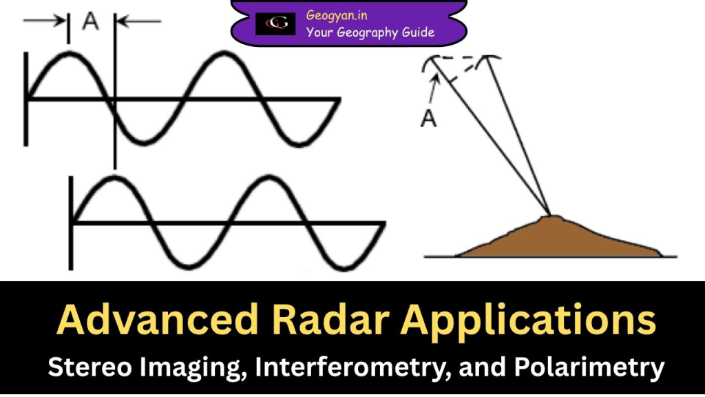
Table of contents
Radar technology has evolved significantly, allowing scientists and researchers to map terrains, measure elevations, and analyze surface features with high precision. Advanced radar applications like Stereo Radar Imaging, Interferometric Radar (Interferometry), and Radar Polarimetry are used in various fields, including forestry, geology, disaster management, and urban planning.
In this article, we will explore these applications, how they work, and where they are used in daily life.
Stereo Radar Imaging: Seeing the World in 3D
Stereo radar imaging works like 3D photography, where two radar images of the same area are taken from different angles to determine terrain height. It is similar to how our eyes perceive depth—each eye captures a slightly different image, and our brain processes them to create a 3D view.
How It Works
- Same-Side Stereo Imaging: The radar captures images from different angles but from the same direction. This method is widely used for forestry, geology, and topographic mapping.
- Opposite-Look Stereo Imaging: The radar captures images from opposite directions (e.g., one looking north, the other looking south). This can create high contrasts, making interpretation difficult, especially in mountainous areas.
Example
Imagine a forest department wanting to estimate the height of trees to study deforestation. Using same-side stereo radar, they can create a detailed 3D map showing tree heights and detect illegal logging activities.
Similarly, geologists use stereo radar maps to study mountain formations and track landslides.
Key Application: Radargrammetry
The process of calculating terrain height from stereo radar images is called Radargrammetry, similar to photogrammetry used with aerial photographs. This is useful for making accurate topographic maps.
Interferometric Radar (Interferometry): Measuring Height with Precision
Interferometry is an advanced radar technique used to measure small changes in terrain elevation. It relies on the phase difference between two radar signals captured from different positions.
How It Works
- Two radar antennas capture the same area at different times or from different positions.
- The difference in wave phase is measured to calculate precise elevation changes.
- This information is processed to create 3D terrain models (called interferograms).
Example
- Earthquake Monitoring: If an earthquake occurs, interferometric radar can detect even centimeter-level ground displacement. Scientists use this data to predict aftershocks and understand fault line movements.
- Volcanic Eruption Prediction: Before an eruption, the ground around a volcano often swells due to magma movement beneath the surface. Interferometry helps monitor these changes to issue timely warnings.
- Urban Planning: Cities use interferometry to detect land subsidence (sinking ground), especially in areas where excessive groundwater extraction causes the land to lower gradually.
Key Advantage
Interferometry provides extreme accuracy, with measurements as precise as a few centimeters, making it crucial for disaster response and environmental studies.
Radar Polarimetry: Seeing More Than the Eye Can Detect
Radar polarimetry enhances imaging by using different polarization combinations (Horizontal-H or Vertical-V) to capture more details about surface properties.
How It Works
- Conventional Radars: Typically use either H or V polarization to send and receive signals.
- Multi-Polarization Radars: Can transmit H or V waves and receive both like- and cross-polarized signals (HH, HV, VH, VV).
- Polarimetric Radars: Capture all four polarization channels, revealing unique surface characteristics.
Example
- Agriculture Monitoring: Farmers use polarimetric radar to analyze soil moisture and crop health. Different crops and soil types reflect polarized signals differently, helping in precision farming.
- Military and Surveillance: Military applications use polarimetry to detect hidden objects, such as camouflaged vehicles or bunkers, by analyzing how radar signals interact with different materials.
- Oil Spill Detection: In marine environments, radar polarimetry helps identify oil spills on water surfaces, as oil and water reflect radar waves differently.
Key Advantage
Polarimetry allows for better detection, classification, and analysis of natural and man-made surfaces, enhancing applications in environmental monitoring, defense, and agriculture.
Conclusion
Advanced radar applications have transformed how we observe and analyze the Earth’s surface.
- Stereo Radar Imaging helps in 3D terrain mapping for forestry and geology.
- Interferometry provides high-precision elevation measurements, crucial for disaster monitoring and urban planning.
- Polarimetry enhances surface feature analysis, benefiting agriculture, defense, and environmental studies.
These technologies play a vital role in everyday life, from predicting earthquakes and monitoring crops to detecting oil spills and mapping forests. As radar systems evolve, their applications will continue to expand, helping scientists, governments, and industries make smarter decisions for a better future.