


Estimated reading time: 8 minutes
Table of contents
Up until recently, archaeologically relevant satellite imagery was only available at relatively low spatial resolution. But with declassified Cold War reconnaissance satellite imagery as well as high-resolution commercial optical satellite products such as Landsat, SPOT, IKONOS and Worldview now making archaeological remote sensing possible, this has changed.
This article will focus on three key areas of archaeological remote sensing: archeological prospection; landscape archaeology and heritage preservation.

The Role of Remote Sensing in Modern Archaeology
Archaeological remote sensing is an invaluable tool for locating, studying, and monitoring archaeological sites and landscapes. Furthermore, it allows researchers to investigate sites in areas where conducting fieldwork would be unsafe, costly, or impossible – providing new research opportunities!
Although archaeology remote sensing offers numerous benefits, its widespread adoption remains limited due to the complexity and cost of satellite imaging technologies as well as an absence of training opportunities for archaeologists and remote sensing specialists alike.
Archaeologists often struggle to navigate through a vast amount of data available and determine which datasets might best support their research projects, let alone how best to access them. This article seeks to ease these barriers by providing a basic overview of free or low-cost remotely sensed datasets available to archaeologists, along with recent archaeological examples from South Caucasus regions. These datasets include optical satellite imagery, multispectral airborne imaging platforms and radar data from the Shuttle Radar Topography Mission (STRM) and PlanetScope radar sensors – each offering different spatial resolution and spectral characteristics suited for archaeological prospection and monitoring applications.
Detection of Archaeological Sites
Archaeologists focus their search for archaeological remains on landscapes with diverse soil types and natural features, which multispectral satellite sensors can identify. Archaeologists typically search landscapes where different soils or features might offer clues that point towards sites containing remains or being of interest for further examination.
GPR (Ground Penetrating Radar) has revolutionized archaeology. GPR works by sending pulses of high-frequency radio waves into the ground, and measuring how long it takes for those signals to reflect off objects or differing layers in the earth and return to an antenna.
It allows archaeologists to access the subsurface of landscapes, potentially uncovering structures or artifacts not visible with other technologies. Furthermore, GPR can also be used to detect looting activities at archaeological sites by sensing changes to earth’s surface properties that could indicate presence of looters.
Remote sensing to detect archaeological sites can be problematic in certain communities as they fear that researchers might disturb their cultural heritage. But when conducted responsibly and with community participation, such research can yield invaluable insight into our past.
Detection of Subsurface Remains
Archaeologists typically rely on shovel test pits to examine subsurface features, but this method can be time-consuming and expensive. Remote sensing technology provides researchers with more effective techniques for discovering possible sites more quickly.
Technology like this can also assist with identifying traces of human activity or structures buried by surface soil or vegetation – especially crucial when looking for ancient Maya ruins in Mesoamerica’s densely forested Peten region.
Ground Penetrating Radar (GPR) is another tool used by RS archaeologists, and this technology sends pulses of radio waves deep into the earth’s layers, measuring how long it takes for their signals to reflect off objects or layers in contrast before returning back to an antenna antenna and being processed into information for interpretation by software identifying subsurface features like buried sites, roads, canals or walls.
However, much remains to be done to expand RS use in archaeology and to reduce barriers that impede widespread adoption (limited availability of free or low-cost satellite imagery and technical complexity associated with analyzing archaeologically significant spatial data (Bennett et al. 2014)
Detection of Changes in the Environment
Archaeological landscapes evolve over time, making archaeological sites even more sensitive to such changes. Radiometric dating (RS) provides the ability to detect these shifts and allow archaeologists to better understand how people interacted with their environment.
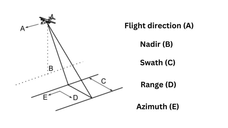
Archaeological satellite imaging can be broadly defined as remote sensing (RS), including both proximal sensing (PS) and in-situ sensing (IS). Historically, archaeological RS has focused on collecting high-resolution optical imagery with geometric accuracy for prospection, site mapping, and heritage monitoring purposes.
Typically, remote sensing sensors work at visible and near infrared wavelengths; however, with advances in digital multispectral imaging radiometers, thermal imaging radars, Lidar, etc. their capabilities have expanded into short wave, middle (thermal) infrared, microwave ranges. These advancements have made archaeology possible by exploring and monitoring an abundance of buried and subsurface features.
Even as remote sensing becomes an integral component of archaeological exploration, certain obstacles remain that limit its effectiveness for heritage research. In-person researchers working in local communities often communicate directly with them and acquire permissions and legal forms from them for work they are conducting; unfortunately there is no equivalent code of conduct for remote sensing research that does not involve direct observation of targets.
Detection of Artifacts
Archaeologists tend to recognize the advantages of satellite remote sensing; however, budgetary restrictions may prevent a full understanding of all available options. Although technical articles on specific datasets have been published, a more general review would prove valuable.
Archaeological projects require a range of EO technologies, from global digital elevation models (DEMs) produced by satellites like Shuttle Radar Topography Mission (SRTM) to high and very high spatial resolution imagery platforms like Satellite Pour L’Observation de la Terre Worldview-3 etc. Each technique offers different spectral, spatial and temporal resolutions but their true value lies in combining all these data points together for analysis and correlation.
Ethical considerations must also be kept in mind when using remotely sensed technology to locate archaeological sites and features, for instance by communicating with local communities as you work and obtaining necessary permissions and legal forms if working in areas that recognize the sacredness of their landscape and limit access.
Test Your Knowledge with MCQs
1. Match the satellite imagery product with its characteristic:
- Landsat A. High-resolution commercial optical satellite imagery
- SPOT B. Declassified Cold War reconnaissance satellite imagery
- IKONOS C. High-resolution commercial optical satellite imagery
- WorldView D. High-resolution commercial optical satellite imagery
Answer:
- Landsat – A
- SPOT – A
- IKONOS – A
- WorldView – A
2. Assertion: Archaeological remote sensing has become possible due to declassified Cold War reconnaissance satellite imagery.
Reason: High-resolution commercial optical satellite products like Landsat, SPOT, IKONOS, and WorldView are now available.
A. Both Assertion and Reason are true, and Reason is the correct explanation for Assertion.
B. Both Assertion and Reason are true, but Reason is not the correct explanation for Assertion.
C. Assertion is true, but Reason is false.
D. Assertion is false, but Reason is true.
Answer: A. Both Assertion and Reason are true, and Reason is the correct explanation for Assertion.
3. Which of the following factors contributed to the advancement of archaeological remote sensing?
A. Declassification of Cold War satellite imagery
B. Availability of high-resolution commercial satellite imagery
C. Both A and B
D. None of the above
Answer: C. Both A and B
4. Match the satellite imagery product with its application:
- Landsat A. Archaeological Prospection
- SPOT B. Landscape Archaeology
- IKONOS C. Heritage Preservation
- WorldView D. All of the above
Answer:
- Landsat – D
- SPOT – D
- IKONOS – D
- WorldView – D
5. Assertion: High-resolution commercial optical satellite imagery has revolutionized archaeological remote sensing.
Reason: This type of imagery provides detailed information about the Earth’s surface.
A. Both Assertion and Reason are true, and Reason is the correct explanation for Assertion.
B. Both Assertion and Reason are true, but Reason is not the correct explanation for Assertion.
C. Assertion is true, but Reason is false.
D. Assertion is false, but Reason is true.
Answer: A. Both Assertion and Reason are true, and Reason is the correct explanation for Assertion.
6. Which of the following is NOT a high-resolution commercial optical satellite product?
A. Landsat
B. SPOT
C. IKONOS
D. Corona
Answer: D. Corona (This was a Cold War reconnaissance satellite program)
7. What was a limitation of archaeologically relevant satellite imagery until recently?
A. High cost
B. Low spatial resolution
C. Limited availability
D. All of the above
Answer: B. Low spatial resolution
8. Which of the following statements is TRUE about high-resolution commercial optical satellite imagery?
A. It is expensive and difficult to obtain.
B. It is only useful for archaeological prospection.
C. It has made archaeological remote sensing possible.
D. It is not as effective as declassified Cold War reconnaissance satellite imagery.
Answer: C. It has made archaeological remote sensing possible.
9. What type of satellite imagery was declassified after the Cold War?
A. High-resolution commercial optical satellite imagery
B. Reconnaissance satellite imagery
C. Multispectral imagery
D. Hyperspectral imagery
Answer: B. Reconnaissance satellite imagery
10. Which of the following is an example of a high-resolution commercial optical satellite product?
A. Corona
B. Gambit
C. Hexagon
D. WorldView
Answer: D. Worldview
FAQs
Declassified Cold War reconnaissance satellite imagery and high-resolution commercial satellite imagery (like Landsat, SPOT, IKONOS, and Worldview) have significantly advanced archaeological remote sensing. These technologies provide detailed images of the Earth’s surface, revealing subtle variations in topography, vegetation, and soil that can indicate the presence of buried archaeological features.
Remote sensing is used for various purposes in archaeology, including archaeological prospection (discovering new sites), landscape archaeology (studying the relationship between sites and their environment), and heritage preservation (monitoring and protecting archaeological sites from damage).
Challenges include the high cost of some technologies and the need for specialized skills to analyze the data. Ethical considerations involve respecting the cultural heritage of local communities and obtaining necessary permissions before conducting remote sensing surveys.


