


Every time the ground shakes in California, even slightly, the question arises: Why does this state experience so many earthquakes? The answer lies hidden beneath the surface—in a vast network of fault lines crisscrossing the region. These invisible fractures in the Earth’s crust have shaped not only California’s landscape but also its history, infrastructure, and way of life. From Hollywood movies dramatizing “The Big One” to real-life emergency drills, fault lines are part of the Californian identity.
But why does California, more than most other places in the U.S., have so many fault lines? Is it just bad luck, or is there a deeper scientific explanation? In this blog, we dive into the earth’s crust (figuratively, of course) to understand the shocking geological truth behind California’s fault lines. Along the way, we’ll uncover how they formed, where they lie, and what they mean for the millions who call this golden state home.
What Are Fault Lines?
Before we dig into California’s unique situation, let’s break down what fault lines actually are.
Fault lines are essentially fractures in the Earth’s crust where blocks of rock have moved past each other. These movements can occur horizontally, vertically, or at an angle. The cause? Tectonic forces generated by the movement of massive plates that make up Earth’s outer shell. Think of the crust as a cracked eggshell – the cracks are the faults.
There are several types of fault lines:
- Strike-slip faults: where two blocks slide past each other horizontally. The famous San Andreas Fault falls into this category.
- Normal faults: where one block drops down relative to the other.
- Thrust (or reverse) faults: where one block is pushed up over the other.
When stress builds up along these faults, the rocks eventually break, releasing energy in the form of an earthquake. Simple in theory. Terrifying in practice.
California’s Tectonic Geography
Now that you understand fault lines, let’s explore why California is their epicenter (pun intended).
California lies at the intersection of two massive tectonic plates: the Pacific Plate and the North American Plate. The Pacific Plate is slowly moving northwest, while the North American Plate is creeping southwest. This opposing motion creates enormous pressure along their boundary, which runs right through California.
The primary fault line created by this boundary is the San Andreas Fault, which stretches more than 800 miles from the Gulf of California to Northern California. But that’s just the headline. Beneath the surface, there’s a tangled web of smaller, interconnected faults that branch off from the San Andreas and crisscross the entire state.
Other major fault systems include:
- Hayward Fault (Bay Area)
- Calaveras Fault (Northern California)
- Elsinore Fault (Southern California)
- Garlock Fault (Eastern California)
Each of these faults plays a role in distributing the stress generated by plate movement. Think of the San Andreas as the trunk of a tree and the others as its sprawling branches.
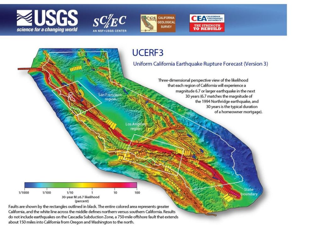
🔎 Explore California’s Fault Lines (Interactive Map)
This interactive USGS map lets you explore real-time fault lines, seismic zones, and active quake regions across California.
Why Are There So Many Faults in California?
So why does California have not just one or two but hundreds of fault lines?
1. Location
California’s unfortunate position right along a major plate boundary is the root of the problem. Unlike the interior of a tectonic plate, which is generally more stable, plate boundaries are dynamic, chaotic, and prone to fracturing.
2. Crustal Deformation
As the Pacific and North American Plates grind against each other, they don’t just move along one clean line. Instead, the pressure causes widespread crustal deformation — twisting, folding, and breaking the Earth’s crust into numerous faults. This deformation is why faults like the Hayward and Garlock exist far from the main plate boundary.
3. A Long Geological History
Over millions of years, different geological events like volcanic activity, mountain building (uplift), and sea-floor spreading have contributed to the formation of new faults across the state.
4. Microplates and Shear Zones
California also has smaller crustal blocks called microplates, like the Sierra Nevada block, which move independently. These create shear zones that generate additional faults, further complicating the geological puzzle.
Put simply, California’s crust is like shattered glass—a complex mosaic of pieces trying to slide past each other.
Real Impact: How Fault Lines Shape Life in California
Living on a fault line isn’t just a science problem—it’s a public safety issue. Here’s how California’s many fault lines influence everyday life:
Frequent Earthquakes
Californians are used to the occasional jolt. While most quakes are small, larger ones occur with troubling regularity. The state experiences around 10,000 earthquakes annually, though most go unfelt.
Infrastructure and Building Codes
California has some of the most stringent earthquake safety standards in the U.S. Buildings, bridges, and highways are designed with fault movement in mind. After the Loma Prieta Earthquake in 1989 and the Northridge Earthquake in 1994, regulations were further tightened.
Emergency Preparedness
From school drills to ShakeAlert (an early warning system), Californians are taught to “Drop, Cover, and Hold On.” The goal? Save lives when the inevitable occurs.
Pop Culture and Public Awareness
Earthquakes and fault lines are embedded in California’s culture. Movies like San Andreas and TV shows regularly dramatize fault-based disasters, sometimes exaggerating reality, but also raising awareness.
What the Future Holds
Despite our growing understanding of fault lines, predicting earthquakes remains notoriously difficult. But science is catching up.
“The Big One”
Geologists warn that the southern section of the San Andreas Fault is overdue for a massive quake. Dubbed “The Big One,” this hypothetical event could cause widespread devastation across Los Angeles and beyond.
Earthquake Monitoring
Organizations like the USGS and Caltech are constantly monitoring seismic activity using thousands of sensors. Data from these tools help scientists identify patterns and stress points.
Early Warning Systems
ShakeAlert, now available as a mobile alert in California, gives people a few seconds to brace before shaking starts. That might not sound like much, but even a 5-second heads-up can save lives.
Resilient Infrastructure
Modern engineering is increasingly focused on resilient design – buildings and bridges that can not only survive an earthquake but remain functional afterward.
Conclusion
California has so many fault lines because it sits at the tense intersection of two major tectonic plates, and millions of years of geological drama have left their mark. From the famous San Andreas to dozens of lesser-known but equally important faults, these cracks in the Earth are both a scientific wonder and a persistent threat.
Understanding these fault lines isn’t just academic – it’s essential for safety, planning, and peace of mind. As Californians continue to build, grow, and live on this ever-moving land, staying informed and prepared is not just smart – it’s necessary.
Whether you’re a resident, a traveler, or just a curious reader, remember: beneath the beauty of California lies a restless Earth, always on the move.
FAQ
Q: What is the biggest fault line in California?
A: The San Andreas Fault is the largest and most well-known, stretching over 800 miles across the state.
Q: Can California break off from the U.S.?
A: No, while it’s a fun idea in movies, tectonic movement doesn’t work that way. The plates slide past, not away.
Q: How often do earthquakes happen in California?
A: Around 10,000 a year, though most are too small to be felt.


