

Lake Tanganyika is one of Africa’s most extraordinary natural wonders. Stretching 673 kilometers (418 miles) long and reaching staggering depths of 1,470 meters (4,823 feet), it holds the titles of:
- World’s second-deepest lake (after Siberia’s Lake Baikal)
- Africa’s longest freshwater lake
- Second-largest by volume (holding about 17% of Earth’s unfrozen freshwater)
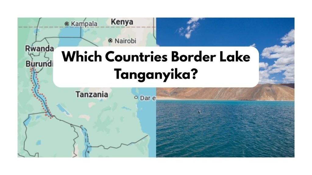
The Four Countries Sharing Lake Tanganyika
Lake Tanganyika’s shores are divided among four African nations. Here is the complete territorial breakdown with precise details most sources miss:
A. Democratic Republic of the Congo (DRC) – ~45% Shoreline
- Key Port Cities: Kalemie, Uvira, Baraka
- Border Length: Approximately 650 km
- Unique Fact: The DRC controls the lake’s deepest sections, including the Tanganyika Trench which plunges to 1,470m
- Economic Importance: Major fishing industry supplying protein to eastern DRC
B. Tanzania – ~41% Shoreline
- Key Port Cities: Kigoma, Mpulungu (shared with Zambia)
- Border Length: About 580 km
- Unique Fact: Home to Gombe Stream National Park where Jane Goodall studied chimpanzees
- Transport Hub: The MV Liemba ferry (a WWI-era ship still operating weekly routes)
C. Burundi – ~8% Shoreline
- Key Port City: Bujumbura (former national capital)
- Border Length: Roughly 110 km
- Unique Fact: Despite having the smallest share, Burundi’s waters are the most heavily fished per square kilometer
D. Zambia – ~6% Shoreline
- Key Access Point: Mbala District (Northern Province)
- Border Length: About 85 km
- Unique Fact: Zambia’s portion includes the scenic Mpulungu Harbor, the country’s only functional port
Why This Border Distribution Matters:
- The DRC and Tanzania control 86% of the lake’s resources
- Border disputes occasionally arise over fishing rights and oil exploration
- Each country manages its section differently, affecting conservation efforts
Exact Border Measurements and How They Were Determined
Unlike man-made borders on land, Lake Tanganyika’s divisions follow natural hydrological boundaries established during colonial times:
Historical Border Agreement
- 1885: Berlin Conference first divided the lake between German East Africa (now Tanzania) and the Congo Free State (now DRC)
- 1919: After WWI, Belgium gained control of what are now Burundi and DRC portions
- 1960s: Independence movements finalized the current four-nation split
Modern Border Coordinates
The most precise measurements come from hydrographic surveys:
| Border Segment | Length (km) | Depth Range (m) |
| DRC-Tanzania | 480 | 200-1,470 |
| DRC-Burundi | 110 | 100-800 |
| Tanzania-Zambia | 85 | 150-500 |
Satellite imaging combined with sonar depth mapping confirmed these boundaries in 2016 under the Lake Tanganyika Authority agreement.
Lake Tanganyika’s Unique Ecosystem (By Country)
Each nation’s shoreline hosts distinct habitats:
DRC Side
- Depth: Contains the lake’s abyssal zone
- Wildlife: Deepwater cichlids found nowhere else
- Threats: Overfishing from refugee populations
Tanzania Side
- Feature: Rocky shores with sandy beaches
- Conservation: Gombe and Mahale Mountains National Parks protect chimpanzees
- Research: Over 20 ongoing scientific studies
Burundi Side
- Characteristic: Shallowest waters
- Issue: Highest pollution levels from Bujumbura
Zambia Side
- Geography: Steep cliffs meeting the lake
- Tourism: Developing scuba diving industry
7 Mind-Blowing Facts About Lake Tanganyika
- Ancient Waters: The lake’s southern basin has not mixed with surface waters in 1,500 years – meaning deep water is essentially prehistoric.
- Bioluminescent Phenomenon: Certain bays glow at night from endemic algae.
- Island Prisons: Zambia’s Mutondwe Island once housed a notorious prison.
- Underwater Forests: Fossilized trees stand upright in deep areas.
- Climate Recorder: Sediment layers contain 100,000 years of climate data.
- Cichlid Evolution: 250+ cichlid species evolved here – Darwin’s finches of the aquatic world.
- Hidden Hot Springs: Submerged geothermal vents create warm oases.