


The Beaufort Sea (Click here to see map) is a remote but strategically vital part of the Arctic Ocean, situated north of Alaska (USA) and Canada’s Yukon and Northwest Territories. Bounded by Prudhoe Bay to the south and connected to the Chukchi Sea via the Barrow Strait, this icy sea spans roughly 476,000 km² (184,000 sq mi) and is known for its harsh Arctic climate, rich oil reserves, and unique wildlife. Below, we explore its exact location, geopolitical significance, and why it is a focal point for climate scientists and energy companies.
Where is the Beaufort Sea Located on the World Map?
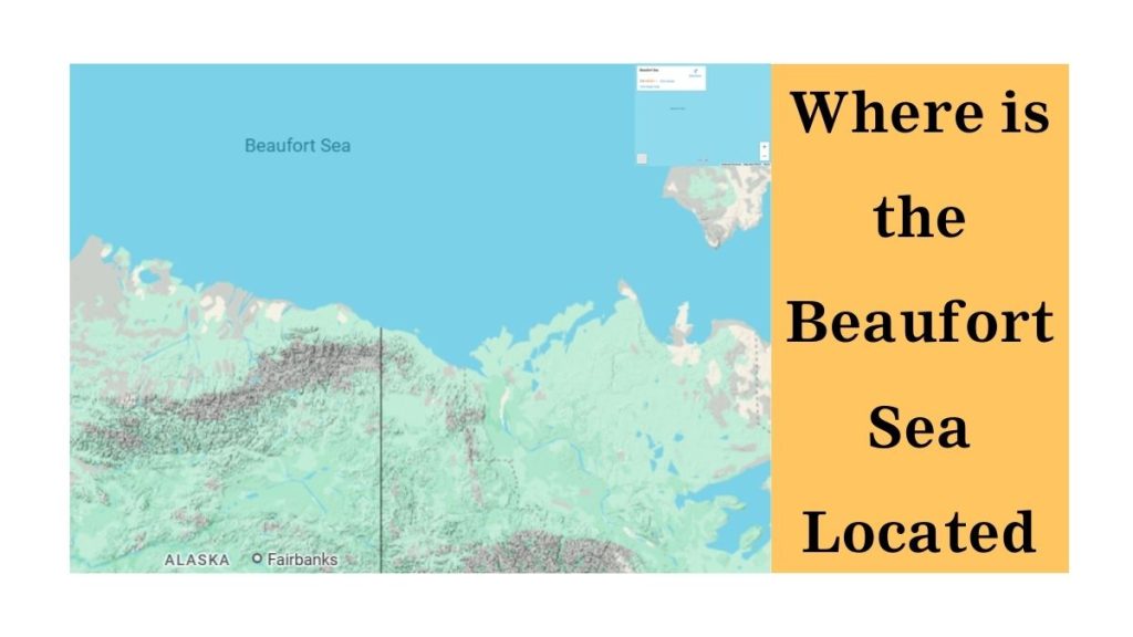
- Coordinates: Between 71°N to 78°N latitude and 120°W to 160°W longitude.
- Bordering Regions:
- North: Arctic Ocean
- East: Canadian Arctic Archipelago
- South: Alaska (USA) & Northern Canada
- West: Chukchi Sea
Which Countries Control the Beaufort Sea?
- United States (Alaska’s North Slope)
- Canada (Yukon & Northwest Territories)
- Disputed Zone: A maritime boundary conflict exists between the U.S. and Canada over a 6,250 km² (2,413 sq mi) wedge-shaped area due to differing interpretations of the 1825 Treaty of Saint Petersburg.
Why is the Beaufort Sea Important?
A. Oil & Gas Reserves
- The Beaufort Sea sits atop massive untapped oil and gas deposits, particularly in the Mackenzie Delta and Prudhoe Bay.
- Major companies like ExxonMobil and Shell have explored drilling, but harsh conditions and environmental concerns have slowed development.
B. Unique Arctic Wildlife
- Home to endangered species like:
- Polar bears (dependent on sea ice)
- Bowhead whales (migrate through its waters)
- Bearded seals & walruses (key food sources for Inuit communities)
C. Climate Change Research
- The Beaufort Sea is a critical indicator of Arctic ice melt, with summer ice shrinking by ~13% per decade (NASA).
- Scientists study permafrost thawing and its impact on global sea levels.
Is the Beaufort Sea Frozen Year-Round?
- Winter (October–June): Nearly 100% ice-covered, making navigation impossible without icebreakers.
- Summer (July–September): Partial melting allows limited shipping and research expeditions.
- Notable Phenomenon: The Beaufort Gyre, a massive circular current that traps Arctic ice and freshwater.
How Deep is the Beaufort Sea?
- Average Depth: ~1,000 meters (3,300 feet)
- Deepest Point: Canada Basin at 4,683 meters (15,364 feet)
- Seafloor Features: Contains submarine canyons and methane seeps, crucial for marine geology studies.
Historical & Geopolitical Significance
- Named After: Sir Francis Beaufort (British hydrographer who devised the Beaufort Wind Scale).
- Indigenous Peoples: The Inuvialuit (Inuit) people have lived along its shores for millennia, relying on its marine life.
- Modern Conflicts: The U.S. and Canada dispute sovereignty over parts of the sea, impacting oil drilling rights.
Threats to the Beaufort Sea
| Threat | Impact |
| Climate Change | Rapid ice loss disrupts ecosystems & Indigenous livelihoods. |
| Oil Spills | Drilling risks catastrophic pollution in fragile Arctic waters. |
| Overfishing | Declining fish stocks threaten food security for local communities. |
Why the Beaufort Sea Matters
The Beaufort Sea is more than just a frozen Arctic expanse—it is a battleground for climate science, energy politics, and Indigenous rights. As ice retreats, its role in global trade and ecology will grow, making it one of Earth’s most watched—and contested—regions.


