The Alboran Sea (Click here to see map) is the westernmost part of the Mediterranean Sea, situated between southern Spain (Europe) and northern Morocco (Africa). It serves as a natural bridge connecting the Mediterranean to the Atlantic Ocean via the Strait of Gibraltar, with surface currents flowing eastward and deeper waters moving westward in a fascinating exchange. Known for its rich marine biodiversity and strategic importance, this sea is a unique blend of ecological wonders, historical trade routes, and modern geopolitical significance.
In this blog, we will explore:
- Exact GPS coordinates and borders (35°N to 37°N latitude, 7°W to 1°W longitude)
- Why it is considered the “lungs of the Mediterranean” due to its oxygen-rich waters
- How its underwater volcanoes and tectonic activity shape the region
- The surprising fact that orcas hunt bluefin tuna in its waters annually
- Why NASA studies its phytoplankton blooms from space
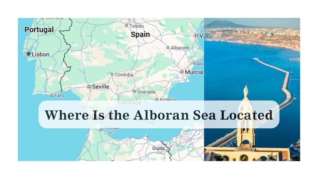
Where Is the Alboran Sea Located?
The Alboran Sea stretches approximately 350 km (220 miles) east to west and 180 km (110 miles) north to south, covering about 53,000 square kilometers. Its boundaries are precisely defined by oceanographers as:
- North: Spain’s Andalusia coast from Tarifa to Cabo de Gata
- South: Morocco’s Rif coastline from Ceuta to Cap des Trois Fourches
- West: The Strait of Gibraltar sill at 300m depth
- East: The Almería-Oran Front, where Mediterranean and Atlantic waters visibly mix
Is the Alboran Sea Part of the Mediterranean?
Yes, it is classified as the Alboran Basin, the first of the Mediterranean’s 7 major sub-basins. What makes it unique is that 70% of its water comes from the Atlantic through the Gibraltar current, which then transforms into Mediterranean water through evaporation.
Why Is It Called the Alboran Sea?
The sea is named after Alboran Island (Isla de Alborán), a tiny 0.07 sq km volcanic rock that’s actually the peak of an undersea mountain rising 1,500m from the seabed. This Spanish-protected territory has:
- A 19th-century lighthouse automated in the 1970s
- The only permanent structure on the island
- A military garrison established in 1967
- Recorded 267 plant and animal species despite its small size
Interestingly, the name “Alboran” comes from the Arabic “Al-Borani,” referring to a 15th-century pirate who used the island as a hideout!
How Deep Is the Alboran Sea?
The Alboran Sea features dramatic depth variations:
- Shallowest point: Just 30m near the Spanish coast
- Deepest point: The Alboran Trough at 2,400m depth
- Average depth: 445m (compared to 1,500m for the Mediterranean)
Its underwater terrain includes:
- The Alboran Ridge (a submerged mountain range with peaks just 100m below surface)
- The Xauen Bank (a prime fishing ground with 500m drops)
- Hydrothermal vents emitting mineral-rich fluids at 1,000m depth
This complex topography creates upwelling zones that bring nutrients to the surface, supporting an extraordinary food chain from plankton to sperm whales.
Which Countries Border the Alboran Sea?
The primary nations are:
- Spain: Controls 65% of the sea’s surface area, including the exclaves of Ceuta and Melilla
- Morocco: Claims fishing rights up to the median line
- Algeria: While not directly bordering, its HBB gas pipeline runs through the eastern Alboran
Territorial disputes:
- Spain and Morocco have competing claims over Perejil Island and fishing zones
- The Chafarinas Islands (Spanish territory just 4km from Morocco) host endangered monk seals
The sea sees 300 commercial ships daily, making it one of the Mediterranean’s busiest lanes.
Why Is the Alboran Sea Important?
A. Ecological Significance
- Hosts 5 cetacean species including fin whales and striped dolphins
- The Alboran Dragonfish (Bathypterois dubius) lives only in its deep trenches
- Posidonia seagrass meadows (UNESCO-protected) store more carbon than rainforests
B. Geopolitical & Economic Role
- Processes $200 billion in annual trade via Gibraltar
- Contains potential methane hydrate deposits being studied for energy
- Spain’s INSTEC military exercises are held here annually
C. Climate Influence
- Acts as a “climate buffer” by absorbing atmospheric CO2
- Its Western Alboran Gyre affects rainfall patterns in North Africa
- Surface temperatures have risen 1.5°C since 1982, faster than global averages
Did You Know? The sea’s western eddies are so powerful they can be seen from space, earning the nickname “the Mediterranean’s whirlpool” among oceanographers.
Which Alboran fact surprised you most? Let us know in the comments!
FAQs About the Alboran Sea
Yes – it sits where the African and Eurasian plates collide, with 20+ measurable quakes annually. The 2016 Alboran Sea earthquake (6.3 magnitude) caused minor tsunamis.
Spain banned drilling in 2022, but Morocco has 5 exploration licenses active.
36.5-38.5 PSU (higher than Atlantic, lower than eastern Mediterranean) due to the mixing of waters.