In recent years, electoral boundary disputes in the United States have once again brought gerrymandering into global focus. After the 2024–25 elections, concerns were raised over how advanced technologies like GIS mapping and data analytics are being used to redraw districts with precision. This has transformed gerrymandering into not just a political issue, but a crucial topic in political geography, highlighting how spatial manipulation can influence democratic outcomes.
What is Gerrymandering?
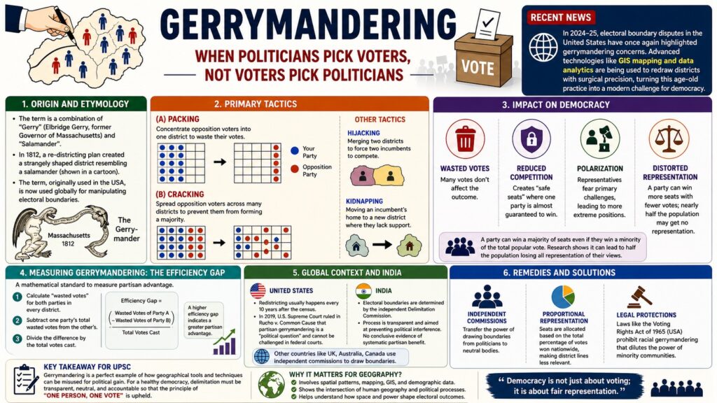
Gerrymandering refers to the deliberate manipulation of electoral district boundaries to favor a particular political party, group, or class. It is often described as a system where politicians choose their voters instead of voters choosing their representatives. This practice distorts the democratic principle of fair representation and creates an imbalance between votes received and seats won.
Origin and Historical Background
The term “gerrymandering” originated in 1812 when Elbridge Gerry, the Governor of Massachusetts, approved a redistricting plan that favored his political party. One of the districts was so oddly shaped that it resembled a salamander, leading to the combination of the words “Gerry” and “Salamander.” Over time, the term has been widely used to describe similar practices across the world.
How Does Gerrymandering Work?
Gerrymandering primarily operates through two key strategies. The first is packing, where voters of the opposing party are concentrated into a single district, allowing them to win that district by a large margin but reducing their influence elsewhere. The second is cracking, where opposition voters are spread across multiple districts so that they fail to form a majority in any of them. Other methods include hijacking, which forces two incumbents to compete in the same district, and kidnapping, which shifts a leader’s constituency to an unfamiliar area.
Why is Gerrymandering a Threat to Democracy?
Gerrymandering significantly affects democratic functioning. It leads to wasted votes, where excess votes do not contribute to electoral victory. It also reduces competition by creating “safe seats” where one party is almost guaranteed to win. This often results in political polarization, as representatives cater only to their core supporters. In extreme cases, it can distort representation to such an extent that a party winning fewer total votes still secures a majority of seats.
What is the Efficiency Gap?
The Efficiency Gap is a method used to measure the extent of gerrymandering. It calculates the difference in wasted votes between two parties and divides it by the total number of votes cast. A higher efficiency gap indicates a greater level of electoral bias. This concept has become important in political geography as it provides a quantitative way to evaluate fairness in electoral systems.
Global and Indian Context
In India, electoral boundaries are determined by the independent Delimitation Commission, which helps ensure transparency and fairness. Unlike in some countries, there is limited evidence of systematic partisan manipulation. In contrast, in the United States, the Supreme Court ruling in Rucho v. Common Cause stated that partisan gerrymandering is a political issue and not subject to federal judicial review. Many countries like the UK, Canada, and Australia have adopted independent commissions to prevent such practices.
Geographical Perspective of Gerrymandering
From a geographical point of view, gerrymandering is deeply connected to spatial distribution and mapping techniques. It involves the strategic use of population density, demographic patterns, and cartographic tools to design electoral districts. With the rise of GIS technology, this manipulation has become more precise and data-driven. Therefore, it stands as a classic example of the intersection between Geography and Polity.
In the end we can say, for a healthy democracy, the delimitation of constituencies must remain neutral, transparent, and data-driven. While technological advancements have made gerrymandering more precise, mechanisms like independent commissions and mathematical tools such as the efficiency gap provide hope for fair representation. Ultimately, ensuring the principle of “one person, one vote” remains the cornerstone of democratic governance.
FAQs (Frequently Asked Questions)
Q1. What is gerrymandering in simple terms?
Gerrymandering is the manipulation of electoral boundaries to benefit a particular political party or group.
Q2. Why is gerrymandering important for UPSC?
It is important because it links political geography, governance, and democracy, making it relevant for both GS Paper I and II.
Q3. Does gerrymandering happen in India?
India has safeguards like the Delimitation Commission, so large-scale gerrymandering is not evident.
Q4. What is the efficiency gap?
It is a method to measure unfair advantage in elections by comparing wasted votes.