Temporal Resolution in Remote Sensing

In remote sensing, the quality of satellite images depends on different types of resolution: spatial, spectral, radiometric, and temporal. While spatial resolution tells us how detailed an image is, and spectral resolution helps differentiate objects based on color, temporal resolution is all about time—how often a satellite captures images of the same location.
How Does Radiometric Resolution Affect Satellite Image Quality?

When analyzing satellite images, we often focus on how clear and detailed they appear. While spatial resolution determines the arrangement of pixels, the radiometric resolution defines the actual information content in an image.
Why Spectral Resolution Matters in Remote Sensing Technology

Discover the world of spectral resolution in remote sensing technology! This crucial concept affects how well sensors can differentiate between wavelengths of the electromagnetic spectrum, influencing our ability to identify land features and vegetation. Imagine distinguishing various rock types or plant species with precision. Join us as we explore the significance of spectral resolution, its applications, and how advanced sensors are enhancing our understanding of Earth’s surface. Don’t miss this enlightening journey!
How Spatial Resolution, Pixel Size, and Scale Affect Remote Sensing

Remote sensing is transforming how we analyze our world, from urban planning to environmental monitoring. What determines the quality of the images we rely on? Explore spatial resolution, pixel size, and scale—essential factors influencing satellite imagery detail and clarity. Whether capturing city details or monitoring large landscapes, understanding these elements is crucial for effective data interpretation. Join us as we delve into remote sensing and its applications!
Satellite Characteristics: Orbits and Swaths

Satellites are the unsung heroes of our daily lives, capturing high-resolution imagery that influences everything from weather forecasts to GPS navigation. But how do these remarkable machines work? Discover the world of satellite orbits and swaths, where geostationary satellites provide continuous monitoring, while near-polar and sun-synchronous satellites ensure consistent global coverage. Learn how these technologies aid in environmental studies, disaster management, and even agricultural optimization.
Characteristics of Images in Remote Sensing

Remote Sensing Images: Understand the key characteristics including digital image representation, channels, bands, and single/multiple channel display.
Passive vs Active Remote Sensing
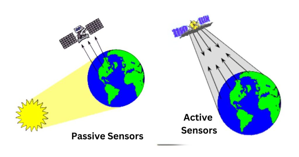
Remote sensing systems are broadly categorized into passive vs active Remote sensing. Both types have unique characteristics, advantages, and applications. Let’s explore them in detail.
Radiation-Target Interactions: Key Concepts in Remote Sensing

Radiation plays an important role in remote sensing as it interacts with the Earth’s surface in different ways.
Interactions of Radiation with the Atmosphere: Understanding Radiation and Remote Sensing

Understanding these Interactions of Radiation with the Atmosphere is crucial for remote sensing applications and for comprehending atmospheric phenomena like the blue sky, sunsets, and greenhouse effects.
The Electromagnetic Spectrum: Understanding the Basics

The electromagnetic spectrum is a continuous range of electromagnetic waves that vary in wavelength and frequency.
Electromagnetic Radiation: A Fundamental Concept in Remote Sensing

Electromagnetic radiation (EMR) is a key element in remote sensing, enabling the observation and analysis of objects from a distance.
Remote Sensing: Meaning, Definition and Process

Remote sensing is a powerful technology used to gather information about the Earth’s surface without direct contact. It plays a crucial role in various scientific and practical applications, including weather forecasting, environmental monitoring, agriculture, and disaster management.
Digital Images and Photographs in Remote Sensing

“Learn the key differences between digital images and photographs in remote sensing. Discover how digital images are captured, processed, and analyzed for various applications, and understand the benefits of digital formats over traditional photographs.”
Types of Remote Sensing

This blogpost explores the various types of remote sensing, including airborne and spaceborne platforms, active and passive sensors, and their applications in agriculture, environmental monitoring, and disaster management.
National Remote Sensing Centre (NRSC)

Discover the role of India’s National Remote Sensing Centre (NRSC) in satellite data acquisition, disaster management, and geospatial services. Learn how NRSC’s cutting-edge technology and capacity-building initiatives contribute to national development and good governance.