Great Lakes: Map | Formation | Importance and More!

Lake Superior is renowned for its incredible vastness and profound depths, proudly holding the title of being the largest freshwater lake on the planet. Its rugged shoreline, picturesque cliffs, and pristine beaches attract visitors seeking solitude and natural beauty.
The Deserts of China and Mongolia: A Journey through Arid Landscapes

Explore the captivating deserts of China and Mongolia, from the arid Gobi Desert to the sandy expanses of the Taklimakan Desert. Discover their unique climate, vegetation, and the challenges they face. Uncover the secrets of these ancient landscapes and learn about ongoing conservation efforts.
Unveiling the Landscapes of North Africa: The Sahara Desert and the Sahel

Here, we will embark on an exciting journey to explore the vastness and unique characteristics of North Africa, focusing on the awe-inspiring Sahara Desert and the transitioning Sahel region. Covering an astounding area of 9,149,000 square kilometer, the Sahara Desert is larger than the continental USA.
The Great Basin Desert and Colorado Plateau

Adjacent to the Great Basin, the Colorado Plateau showcases a contrasting tectonic style and landscape. This roughly circular region spans approximately 384,000 square kilometer, encompassing parts of Utah, Colorado, New Mexico, and Arizona.
The Mojave Desert: A Natural Marvel of Southeastern California and Southern Nevada

Discover the Mojave Desert, North America’s smallest desert, boasting a triangular shape that covers approximately 140,000 km2 across southeastern California and southernmost Nevada. With its elevated terrain distinguishing it as the “high desert,” the Mojave stands apart from the neighboring Sonora Desert.
Exploring the Sonoran Desert: A Unique and Diverse Ecosystem

The Sonoran Desert, spanning approximately 275,000 km2, is a remarkable region known for its distinctive flora, varied topography, and subtropical climate. Located in the northern two-thirds of the Gulf of California, primarily in the Mexican state of Sonora, this desert stretches across the Baja California peninsula, reaching the open Pacific coast.
Chihuahuan Desert: A Universe of Astonishments, Unveiling its Concealed Treasures

Nestled amidst the Rio Grande and the Sierra Madre Occidental, the Chihuahuan Desert extends over roughly 140,000 square miles, encompassing an assortment of distinct ecosystems and habitats. While deserts often evoke images of barrenness, the Chihuahuan Desert defies expectations with its awe-inspiring biodiversity and mesmerizing landscapes.
International Date Line
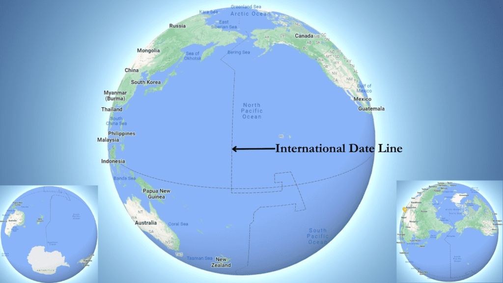
The International Date Line is an imaginary line located roughly along the 180th meridian in the Pacific Ocean. It serves as the line of demarcation between two consecutive calendar days and is the place where the day changes first.
Local Time and Standard Time: A Guide to Timekeeping Around the World

Local time refers to the time in a certain area, which is determined by the position of the sun in the sky and the line of longitude that passes through it. This means that local time varies from region to region, so it is important to have a standard time system. Standard time is based […]
Arab Geographers’ Contributions to Geography

Arab geographers in the medieval period made significant contributions to geographical knowledge by emphasizing direct observation, logical deduction, and the use of a variety of sources. They enriched the geographic horizon due to the spread of Islam and the consolidation of Arabic-speaking people.
12 Factors Affecting Localization of the Cotton Textile Industry

Textile Industry Clothes are the second basic need of human beings after food. Textile manufacturing industry is the oldest industry in the world. Since ancient times, textile manufacturing was done in countries like India, China, Egypt, Peru, and Mexico. The English word textile is derived from the Latin word ‘texture’, which means ‘to weave. Today, […]
Mountain

Mountains are the relief of the second order on the earth’s surface. They are 1,000 m higher than the adjacent areas and characterized by a lateral steep slope and narrow summit. Mountains whose height is less than 1,000 m are called hills. The top or the highest part of a mountain or hill is called […]
Geological History of the Earth

At present, the history of the earth is divided into several Eras. These eras are again arranged sequentially into Epochs. Each epoch is again divided into periods known as Shakas (Period).
Indian Border with adjacent Countries

India is situated between the Himalayan Mountains and the Indian Ocean, therefor it has both terrestrial as well as water frontiers. Land or Terrestrial boundary The terrestrial boundary of India is about 15,106 km long. It is bounded by Pakistan and Afghanistan in the northwest, China, Nepal, and Bhutan in the north, and Myanmar & […]
Standard Meridian of India

Why is India’s breadth of 2,933 km (from East to West) less than its length of 3,214 km (from North to South) by 281 km however both the latitudinal and longitudinal extents are 30 degrees.